- 0
-
Your Responses - Share & Have Fun :)
-
-

-

By fishingstar · Posted
take her and fin to a boat landing and through a tennis ball off it. She will swim or fin will get all the balls. -

By monstermoose78 · Posted
Cold you all see the video -
By Mike89 · Posted
she looked like she was having fun!!! never seen a lab that couldn't swim!!! -
By monstermoose78 · Posted
I got a lab who can’t swim right! IMG_7751.mov -
By smurfy · Posted
Well this sucks, brother is at the cabin. This is about a 4 year old Yamaha 700, what's left of it. It's insured. Not sure how the fire dept got to it, not much more then a wheeler trial -
By jparrucci · Posted
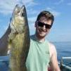
57 this morning, dramatic change from last weekend. Fish were biting when you could keep the boat at a steady pace, wind is howling. Lots of small walleye some keepers tossed in. -
-
By Kettle · Posted
Yesterday morning hunt. Headed home for 3 weeks then coming back
-
Question
Ed Carlson
Just when ya think ya have all the "Stuff" ya need....they do it to ya again.
LakeMaster has released a new PC mapping program that is to say the least, sweet....so Fish'n Tech Nerds...rejoice.
It's called the Contour Elite series. And ya...it's preaty darn Kewl.
Currently available in Contour Elite for Minnesota, and Contour Elite for Wisconsin. I hoping the ND/SD, and LOTW Rainy is next.
I'm very impressed at the wide range of units it will interface with, and grown with...it is smart...the more you use it, the more refined your mapping becomes....very sweet.
Link to comment
Share on other sites
8 answers to this question
Recommended Posts
Join the conversation
You can post now and register later. If you have an account, sign in now to post with your account.
Note: Your post will require moderator approval before it will be visible.