Jump to content
  • GUESTS

    If You  want access  to member only forums on FM, You will need to Sign-in or  Sign-Up now .

    This box will disappear once you are signed in as a member.

GPS structure Trick in Snow


IceHawk

Recommended Posts

  • 'we have more fun' FishingMN Builders

Been doing this for years on my sled. ?

  • Thumbs Up 2
  • I Like it 1
Link to comment
Share on other sites

3 hours ago, IceHawk said:

Now that we have some nice new fresh snow on Lakes I thought I would give out a little trick of mine that I use when Walleye fishing all winter if there's snow on ice . . This works with ATVS, Snowmobiles, and Trucks. Most of us have summer setups electronics  in our boats. Why not take advantage of them in winter. Before putting your boat away for summer pull one of your Locators off if GPS compatible and mount it on a Blue box  suction cup for Truck or Ram mount on ATV  or Snowmobile. If you don't have a chip buy a lake master, lake insight or Navionics. Whatever is sufficient for your brand of electronics. Next get a game plan together on your depths  you want to fish according to the  ice period your fishing early mid late winter.  Go out to a lake after a nice fresh snowfall and basically follow the break lines points etc with your mode of transportation just like you would in your boat. Once you have laid a path out on your depth go back and cut holes in your trucks wheel tracks saves piles of time and keeps you on a designated depth you are targeting saveing lots of time. Right now I have my Lowrance Elite 7 mounted on a suction cup on windshield in my truck. When I get on a lake and want to fish a underwater point I will first decide on depths I intend to fish  set my course to follow that depth keeping constant eyes on my electronics to stay on that depth just like I was in my boat. First I will start  off close to the  shoreline and follow that depth   to tip around tip back to  opposite shoreline. Staying exactly on depths I want to fish, Walk out stand back and look at your trail in fresh snow you will see exactly how that piece of structure is laid out. It shows obvious knobs,  tip of point inside corners etc. . Then go out with your auger and pound a series of holes every 15 foot or so in your vehicles wheel tracks all the way around your trail, as they will be right on the depths you want to target. . Next I Ice troll all these holes during day giving each hole only a minimal amount of time  before moveing on, until I hook a fish or two. The location hooking of active fish useally dictates where I want to be setup before prime time to capitalize on that prime bite.  This technique has proven itself for me over and over on many lakes. Works like a charm on the Millacs mudflats. or if you want to target the edge of a nice weed line. 

You could put navionics app on phone and do same thing.  

  • Thumbs Up 2
  • I Like it 1
Link to comment
Share on other sites

  • Official Fishing Report Team - MN
6 minutes ago, delcecchi said:

You could put navionics app on phone and do same thing.  

Yes and I have it  on my phone use it occasionally walking out  as many do.  You could put it on a kindle or a  tablet and it also would work.,   but I honestly don't think there as accurate  But this may just be my opinion and I may be wrong.  How many guides charter captions rely on the safety of there clients with a phone? There's a reason why they run top GPS plotters accuracy.  I can tell you from experience some lakes are not mapped by Navionics well and are inaccurate.  Some lakes are  way better mapped detailed and accurate with a Lake Master or Lake insight chip. So having multiple options is key depending on the lakes you fish.  Try comparing  your phone accuracy to a GPS chip on a Top quality Lowrance Humminbird  or other GPS system.  Set a waypoint and use the two to your destination and you might surprise yourself the phones accuracy to spot on spot.. Another negative way to small for me to see driving, Ill utilize the locators on the boat. Kind of makes sense when there are 4 of them on there to pull one off and get some multi use out of it. 

  • Thumbs Up 1
  • I Like it 1
Link to comment
Share on other sites

9 hours ago, Dave S said:

Based on what I've found, the Navionics app on a phone only gets you within 100 feet. The triangulation off cell towers will be nowhere near as accurate as a gps. It's still helpful but it requires drilling a few more holes to get on any given structure accurately.

Correct, smart phones use cell tower triangulation to improve GPS accuracy. Without towers accurcy is about 100 feet. That's why I chose the Samsung Tab A 10.1" tablet which uses GPS/GLONASS chip set with 2.8 to 7.2 meter accurcy (8 to 20 ft.) with most time at 3 meter or less including 30 miles off shore in the Gulf of Mexico. Until 2018, Garmin, Humminbrid used thhe GPS chip set, 15 meter accurcy than adding GPS/GLONASS or GPS/WAAS chip sets with 3 meter accurcy. GPS is U.S.A and GLONASS is Russian. 

For contour maps I use both Navionics Boating and Humminhbird FishSmart (Lakemaster) maps. Some lakes more accurate on Navionocs others on Lakemasrer. Lakemaster bit more expensive at $10 per lake where Navionocs $15 annual for all lakes. I tend to use Boating as it has many more features - remapping contours, 5 contour color sets, one touch "On-The-Fly" marker at GPS location. 

My next buy will be the first tablet that uses the Broadcom GNSS dual chipset with 10 centermeter (4 inch) accurcy.  Lots of talk about Samsung S10 phone having the chipset in 2019 but did not happen. May see a puck out soon to connect to an android app.

  • Thumbs Up 2
  • Thanks 2
Link to comment
Share on other sites

  • 'we have more fun' FishingMN Builders
50 minutes ago, papadarv said:

Correct, smart phones use cell tower triangulation to improve GPS accuracy. Without towers accurcy is about 100 feet. That's why I chose the Samsung Tab A 10.1" tablet which uses GPS/GLONASS chip set with 2.8 to 7.2 meter accurcy (8 to 20 ft.) with most time at 3 meter or less including 30 miles off shore in the Gulf of Mexico. Until 2018, Garmin, Humminbrid used thhe GPS chip set, 15 meter accurcy than adding GPS/GLONASS or GPS/WAAS chip sets with 3 meter accurcy. GPS is U.S.A and GLONASS is Russian. 

For contour maps I use both Navionics Boating and Humminhbird FishSmart (Lakemaster) maps. Some lakes more accurate on Navionocs others on Lakemasrer. Lakemaster bit more expensive at $10 per lake where Navionocs $15 annual for all lakes. I tend to use Boating as it has many more features - remapping contours, 5 contour color sets, one touch "On-The-Fly" marker at GPS location. 

My next buy will be the first tablet that uses the Broadcom GNSS dual chipset with 10 centermeter (4 inch) accurcy.  Lots of talk about Samsung S10 phone having the chipset in 2019 but did not happen. May see a puck out soon to connect to an android app.


Well you learn something new ever day. I'm a Grownass-man and have had maybe 10 different GPS units over the years, and never heard of Glonass?  Do those Russkis use some of our stuff or did they shoot their own junk up dar?  ?

  • l Love It 1
Link to comment
Share on other sites

1 hour ago, leech~~ said:


Well you learn something new ever day. I'm a Grownass-man and have had maybe 10 different GPS units over the years, and never heard of Glonass?  Do those Russkis use some of our stuff or did they shoot their own junk up dar?  ?

GPS, the USA global system has 33 active satellites circling the earth put up with US rockets. GLONASS has 24 satellites circling the north half of the world the Ruskies put in the air on their rockets. WAAS has 3 satellites and 48 ground stations developed by the Federal Aviation to correct GPS errors, provide vertical position for aircraft landing assistance during nasty weather conditions. GNSS is the new Broadcom chip-set having 2 channels merging all GPS data to achieve the 10 centermeter accurcy. All this is probably much more information all of us Grownass-men really care to know.

  • Thumbs Up 1
  • Yayyyy 2
Link to comment
Share on other sites

  • Official Fishing Report Team - MN
57 minutes ago, smurfy said:

i'm just putting a tracking device on icehawks vehicle!!!!!!!!!!!?

? So your saying I need to search under my truck before I head out ?  Seriously you more than welcome to join me anytime it would be fun just let me know.  I always have room in the truck if not ill make room. ? Be tackleing a lot of local water this week close to our backyards. I have to find a few good spots hot bites  for a few wheel house placements for upcomeing weekend.  

  • I Like it 1
Link to comment
Share on other sites

  • 'we have more fun' FishingMN Builders
2 hours ago, papadarv said:

GPS, the USA global system has 33 active satellites circling the earth put up with US rockets. GLONASS has 24 satellites circling the north half of the world the Ruskies put in the air on their rockets. WAAS has 3 satellites and 48 ground stations developed by the Federal Aviation to correct GPS errors, provide vertical position for aircraft landing assistance during nasty weather conditions. GNSS is the new Broadcom chip-set having 2 channels merging all GPS data to achieve the 10 centermeter accurcy. All this is probably much more information all of us Grownass-men really care to know.


Darn, yep.  I just wanta find my same luck Ice hole again on another day!  Hope them GLONASSGPS folks don't screw with things and I lose my spot! ☹️

  • Confused 1
  • Yayyyy 1
Link to comment
Share on other sites

18 hours ago, Dave S said:

Based on what I've found, the Navionics app on a phone only gets you within 100 feet. The triangulation off cell towers will be nowhere near as accurate as a gps. It's still helpful but it requires drilling a few more holes to get on any given structure accurately.

My phone, like most, has a GPS built in.  You might want to check your settings.   Although I don't know if they use WAAS. 


I use a "map my walk" app and it tracks me within like 10 feet when I am out walking on the bike paths.

Edited by delcecchi
  • Thumbs Up 3
Link to comment
Share on other sites

4 hours ago, delcecchi said:

My phone, like most, has a GPS built in.  You might want to check your settings.   Although I don't know if they use WAAS. 


I use a "map my walk" app and it tracks me within like 10 feet when I am out walking on the bike paths.

Time to eat a bit of crow. Del is most likely correct on android cell phone GPS after 2017. My Galaxy J 2017 build has the Glonass/GPS chip set, same 3 meter accurcy as my tablet. If you desire to know the type and accurcy of your android phone, install the GPSTest app from Play Store. It will show you what satellites your receiving and accuracy of your GPS. I don't have an iPhone so don't have info on iPhone Gps.  

  • Thumbs Up 1
  • Thanks 1
Link to comment
Share on other sites

Iphones have GPS also.    In fact I think it might have become an FCC requirement to have GPS in order to support 911 calling.


You can turn off "location services" on phones to save power.

  • Thumbs Up 1
  • Thanks 1
Link to comment
Share on other sites

On 1/18/2020 at 10:45 PM, Dave S said:

Based on what I've found, the Navionics app on a phone only gets you within 100 feet. The triangulation off cell towers will be nowhere near as accurate as a gps. It's still helpful but it requires drilling a few more holes to get on any given structure accurately.

Don't most phones also have the ability to use satellite for GPS? My Galaxy S6 Active does in addition to using mobile networks and wi-fi. That way too, I do not need a network connection to find my location.


Oops, should have finished reading through the rest of the posts as this was already addressed.

Edited by BobT
  • Thumbs Up 1
Link to comment
Share on other sites

28 minutes ago, BobT said:

Don't most phones also have the ability to use satellite for GPS? My Galaxy S6 Active does in addition to using mobile networks and wi-fi. That way too, I do not need a network connection to find my location.


Oops, should have finished reading through the rest of the posts as this was already addressed.

I might add that on my android phone "Location" is under "connections" in Settings, offers 3 choices.   GPS, GPS and Network, Network only.

Link to comment
Share on other sites

3 hours ago, delcecchi said:

Iphones have GPS also.    In fact I think it might have become an FCC requirement to have GPS in order to support 911 calling.


You can turn off "location services" on phones to save power.

Right on Dell. All phones as of 2018 have GPS chip sets - FCC required.

https://www.techspot.com/news/45751-fcc-requires-all-mobile-phones-gps-capable-2018.html

  • Thumbs Up 1
  • Thanks 1
  • l Love It 1
Link to comment
Share on other sites

On 1/20/2020 at 1:11 PM, papadarv said:

Right on Dell. All phones as of 2018 have GPS chip sets - FCC required.

https://www.techspot.com/news/45751-fcc-requires-all-mobile-phones-gps-capable-2018.html

Actually I am surprised that the fcc thing was that recent.  BTW many or all cell phones have a magnetic compass and a level built in.


If you want to check them out, just go to app store and browse around.

  • Thumbs Up 1
  • Thanks 1
Link to comment
Share on other sites

7 minutes ago, delcecchi said:

Actually I am surprised that the fcc thing was that recent.  BTW many or all cell phones have a magnetic compass and a level built in.


If you want to check them out, just go to app store and browse around.


People are pretty freaked out when I open my level and measuring app.  I use it to level campers and mount scopes on guns the most.


The measure part takes a little bit to get used to but not really hard.  It is dead accurate too.

6C017FFB-BEE8-4F96-BB6E-5D37E19786FB.thumb.jpeg.a04e5218ecdefa968dd3eee73381d2c6.jpeg

  • Thumbs Up 1
  • l Love It 1
Link to comment
Share on other sites

Join the conversation

You can post now and register later. If you have an account, sign in now to post with your account.
Note: Your post will require moderator approval before it will be visible.

Guest
Reply to this topic...

×   Pasted as rich text.   Restore formatting

  Only 75 emoji are allowed.

×   Your link has been automatically embedded.   Display as a link instead

×   Your previous content has been restored.   Clear editor

×   You cannot paste images directly. Upload or insert images from URL.


  • Similar Content

  • Your Responses - Share & Have Fun :)

    • jparrucci
      Very low, probably 2 feet lower than last year at ice out.
    • mbeyer
      what do they look like this spring?
    • SkunkedAgain
      I might have missed a guess, but here are the ones that I noted:   JerkinLips – March 27th, then April 7th Brianf. – March 28th Bobberwatcher – April…. MikeG3Boat – April 10th SkunkedAgain – early April, then April 21st   Definitely a tough year for guesses, as it seemed to be a no-brainer early ice out. Then it got cold and snowed again.
    • mbeyer
      MN DNR posted April 13 as Ice out date for Vermilion
    • Brianf.
      ^^^45 in the morning and 47 in the evening
    • CigarGuy
      👍. What was the water temp in Black Bay? Thanks....
    • Brianf.
      No, that wasn't me.  I drive a 621 Ranger. 
    • CigarGuy
      So, that was you in the camo lund? I'm bummed, I have to head back to the cities tomorrow for a few days, then back up for at least a few weeks. Got the dock in and fired up to get out chasing some crappies till opener!
    • LakeofthewoodsMN
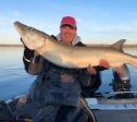
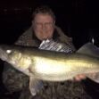
      On the south end...   Lots of ice on the main basin, but it is definitely deteriorating.  Some anglers have been fishing the open water at the mouth of the Rainy River in front of the Lighthouse Gap.  The rest of the basin is still iced over. Pike enthusiasts caught some big pike earlier last week tip up fishing in pre-spawn areas adjacent to traditional spawning areas.  8 - 14' of water using tip ups with live suckers or dead bait such as smelt and herring has been the ticket.  Ice fishing for all practical purposes is done for the year. The focus for the basin moving forward will be pike transitioning into back bays to spawn,  This is open water fishing and an opportunity available as the pike season is open year round on Lake of the Woods. The limit is 3 pike per day with one being able to be more than 40 inches. All fish 30 - 40 inches must be released. With both the ice fishing and spring fishing on the Rainy River being so good, many are looking forward to the MN Fishing Opener on Saturday, May 11th.  It should be epic. On the Rainy River...  An absolutely incredible week of walleye and sturgeon fishing on the Rain Rainy River.     Walleye anglers, as a rule, caught good numbers of fish and lots of big fish.  This spring was one for the books.   To follow that up, the sturgeon season is currently underway and although every day can be different, many boats have caught 30 - 40 sturgeon in a day!  We have heard of fish measuring into the low 70 inch range.  Lots in the 60 - 70 inch range as well.   The sturgeon season continues through May 15th and resumes again July 1st.   Oct 1 - April 23, Catch and Release April 24 - May 7, Harvest Season May 8 - May 15, Catch and Release May 16 - June 30, Sturgeon Fishing Closed July 1 - Sep 30, Harvest Season If you fish during the sturgeon harvest season and you want to keep a sturgeon, you must purchase a sturgeon tag for $5 prior to fishing.    One sturgeon per calendar year (45 - 50" inclusive, or over 75"). Most sturgeon anglers are either a glob of crawlers or a combo of crawlers and frozen emerald shiners on a sturgeon rig, which is an 18" leader with a 4/0 circle hook combined with a no roll sinker.  Local bait shops have all of the gear and bait. Up at the NW Angle...  Open water is continuing to expand in areas with current.  The sight of open water simply is wetting the pallet of those eager for the MN Fishing Opener on May 11th.   A few locals were on the ice this week, targeting pike.  Some big slimers were iced along with some muskies as well.  If you like fishing for predators, LOW is healthy!  
    • Brianf.
      Early bird gets the worm some say...   I have it on good authority that this very special angler caught no walleyes or muskies and that any panfish caught were released unharmed.        
×
×
  • Create New...

Important Information

By using this site, you agree to our Terms of Use and Privacy Policy. We have placed cookies on your device to help make this website better. You can adjust your cookie settings, otherwise we'll assume you're okay to continue.