
-
Your Responses - Share & Have Fun :)
-

By leech~~ · Posted
Nice fish. I moved to the Sartell area last summer and just thought it was windy like this everyday up here? 🤭 -
By Rick G · Posted
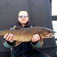
Crazy windy again today.... This is has been the norm this spring. Between the wind and the cold fronts, fishing has been more challenging for me than most years. Panfish have been moving in and out of the shallows quite a bit. One day they are up in the slop, the next they are out relating to cabbage or the newly sprouting lilly pads. Today eye guy and I found them in 4-5 ft of water, hanging close to any tree branches that happened to be laying in the water. Bigger fish were liking a 1/32 head and a Bobby Garland baby shad. Highlight of the day way this healthy 15incher -

By monstermoose78 · Posted
-
By monstermoose78 · Posted
As I typed that here came a hen. IMG_7032.mov IMG_7032.mov -
By monstermoose78 · Posted
So far this morning nothing but non turkeys. -
By monstermoose78 · Posted
Well yesterday I got a little excited and let a turkey get to close and I hit the blind!! -

By smurfy · Posted
good......you?? living the dream..in my basement playing internet thug right now!!!!!! 🤣 working on getting the boat ready.......bought a new cheatmaster locator for the boat so working on that. waiting for warmer weather to start my garden!!! -
By monstermoose78 · Posted
How is everyone doing? Holy moly it’s chilly this morning I stayed in bed and will hunt later today when it warms up. -
By monstermoose78 · Posted
Guys slim creek on burntside is the place to load up on smelt -
By JerkinLips · Posted
My 3rd guess was finally correct. Definitely a moving target this year. Guess Date Ice Out 2/28 3/27 3/12 4/7 4/9 4/13
-
Recommended Posts