Jump to content
  • GUESTS

    If You  want access  to member only forums on FM, You will need to Sign-in or  Sign-Up now .

    This box will disappear once you are signed in as a member.

Recommended Posts

I'm planning a fishing trip to Vermilion this summer. It's been many years since I've been up there.

I have the Navionics + app on my mobile devices and have been marking spots that look interesting.  One of the spots I marked was a nice hump surrounded by deep water. There was a big difference between the Navionics Nautical Chart view and the Sonar Chart view. It literally disappeared on the Nautical view but showed on the Sonar View. I then ran the map "update all" and from the Sonar view now it was gone from both views with my marker out in the middle of nowhere.

So I started to look around for other areas that showed a big difference between the two views. (Many areas however do look very similar on both views) I've attached a couple of screen grabs of a spot that has a huge difference. This is on the north side of Pine Island near Matson Island.

The first is the Nautical Chart view, The second is the Sonar Chart View.

I always thought that the Sonar Chart would be the most accurate, they look more detailed, plus according to Navionics the Sonar Chart is "constantly being updated by Sonar Logs contributed by million of boaters."

I'm not really sure if I can trust either?

To anyone who knows this part of the lake, are there really the holes and humps in this area?  One view shows a 52' hole where the other has 15 FOW.


navionics.jpg

sonar.jpg

Link to comment
Share on other sites

I know that part of the lake fairly well. The Sonar chart is definitely better but I'm still surprised at how inaccurate it is. There are humps etc but they don't have them in the right places.

Link to comment
Share on other sites

Sonar chart is going to be more detailed (obviously). As far as accuracy it’s pretty spot on the most I’ve found navionics to be off is a foot or two usually on steep breaks or humps.

Link to comment
Share on other sites

Wow, I just replicated what you show, and I can confirm the same results.  I did not expect that much of a difference.  Crazy.

  • Yayyyy 1
Link to comment
Share on other sites

I also replicated the differences on my Navionics.  I don't know what to trust now.  I was in 48 FOW on Burntside last weekend and my Navionics said I was in 74 FOW, and I wasn't on a sharp break.

Link to comment
Share on other sites

JL, I’ve fished burtside multiple times and have noticed that it seems to be off all over the lake. That’s the only place I’ve noticed it though.

  • Thanks 1
Link to comment
Share on other sites

The sonar chart that shows 52 feet is totally wrong!

Probably more like 15' to 20' depth.

The Navionics  is probably closest to correct.

Cliff

  • Thumbs Up 1
Link to comment
Share on other sites

Not seeing that when I switch it to sonarchart. I don't have navionics + app though just regular old navionics. For what it's worth I've always been on the navionics setting when I use the phone app on the lake and it's mostly spot on. Actually didn't realize sonarchart existed until now

  • Thumbs Up 1
  • Thanks 1
Link to comment
Share on other sites

2 hours ago, KirtH said:

If you see any issues with mapping follow this link they are very good at fixing issues. 

http://navionics.force.com/PlugPlay?cancel=http%3A%2F%2Fnavionics.force.com%2Fkb&l=en

I actually did follow up on that same  Navionics mapping discrepancy report earlier today. I sent them the same images that I posted here.

More or less just curious to see what the response would be.

It is interesting to see that community sonar readings can be used to improve mapping software but it looks as though it's not quite perfected yet.

Link to comment
Share on other sites

I have had the app for several years.  The first thing I noticed on the old app, was a series of trenches in North Niles Bay.  I skeptically went out there first thing to check it out and found nothing.  A few years later, their update corrected the issue. Found many other inaccuracies since then.   I would give the app low marks for accuracy but good marks for functionality.  It is a serviceable for scouting, navigating and marking your spots.  I do use it on ice.   I heard that Garmin did a full lake survey last year.  I am looking forward to their product.   It should be good.  

  • Thumbs Up 1
Link to comment
Share on other sites

Garmin acquired Navionics last October.  That could mean some improvements in the future.

If you have the plus version of the app you can get the updates. Every few days I hit update all.

It just about always has an update to download. If Garmin just completed a survey of Vermilion maybe Navionics will become more accurate.

Link to comment
Share on other sites

I have the LakeMaster chip on my Garmin GPS.  It doesn't have increments finer than 5 feet but does seem to be accurate.  Anybody else have an opinion on the LakeMaster maps?

Link to comment
Share on other sites

My brother has one in his lowrwnce handheld. He’s had that for 10+ years. It seems fine. I do notice navionics is more detailed somtimes but others it’s the opposite. It does it’s job well.

  • Thanks 1
Link to comment
Share on other sites

1 hour ago, JerkinLips said:

I have the LakeMaster chip on my Garmin GPS.  It doesn't have increments finer than 5 feet but does seem to be accurate.  Anybody else have an opinion on the LakeMaster maps?

I had them for years and other than the 3 foot contours thing, I found them to be pretty good.  Now using Lake insight that was bundled with my Lowrance elite units, and it looks just like the lakemaster data.  No complaints. 

  • Thanks 2
Link to comment
Share on other sites

Both Lake Master and Navionics chips work fine on Vermilion.

Cliff

  • Thanks 1
Link to comment
Share on other sites

Just received this email from Navionics:

Thank you for bringing your concerns to our Cartography Department.   Navionics appreciates your input.  We anticipate an update will be made available by 30 MAR 2018. I will contact you with instructions to receive the update once it has been released. Please do not hesitate to contact us if you have any questions.

Best regards,

Jennifer Pereira
Navionics Customer Service

  • Thumbs Up 2
Link to comment
Share on other sites

BTW, I do have Navionics+ but I let the app expire because I preferred the Lake Master.  But I will renew my Navionics in the hope that the Garmin influence will improve their maps.  

Link to comment
Share on other sites

On 3/9/2018 at 4:18 PM, mdogdaddy said:

Just received this email from Navionics:

Thank you for bringing your concerns to our Cartography Department.   Navionics appreciates your input.  We anticipate an update will be made available by 30 MAR 2018. I will contact you with instructions to receive the update once it has been released. Please do not hesitate to contact us if you have any questions.

Best regards,

Jennifer Pereira
Navionics Customer Service

Well, in less than a week Navionics followed up on the update.  I checked the Web app since it is an auto update and the new sonar view was there. Who knows maybe they improved on the rest of the lake since it was all charted last year.


Sonar2.jpg

Nautical-2.jpg

Link to comment
Share on other sites

Interesting.  I had let my Navionics+ subscription expire, so I went and checked my map for the area above, and it still has the old, incorrect sonar map.  I still get application updates that show up for the app, but obviously that does not include map updates.  And when I go to the Menu and click on updates, it immediately reminds me it is expired.  So when the app is expired, it looks like it is then a static map from the day it expired, no map updates.

Link to comment
Share on other sites

My Navionics app is so old that it doesn't even have an update option. It talks about having 3G and iphone 4s. I'm on version 5.0.4 with a GeoCore version of 01.00.03.

I assume that I would need to re-purchase the app to get anything useful, but I still find this old version to be helpful.

Link to comment
Share on other sites

Join the conversation

You can post now and register later. If you have an account, sign in now to post with your account.
Note: Your post will require moderator approval before it will be visible.

Guest
Reply to this topic...

×   Pasted as rich text.   Restore formatting

  Only 75 emoji are allowed.

×   Your link has been automatically embedded.   Display as a link instead

×   Your previous content has been restored.   Clear editor

×   You cannot paste images directly. Upload or insert images from URL.


  • Similar Content

  • Your Responses - Share & Have Fun :)

    • mulefarm
      With the early ice out, how is the curlyleaf pondweed doing?
    • LakeofthewoodsMN
      On the south end...   The big basin, otherwise known as Big Traverse Bay, is ice free.  Zippel Bay and Four Mile Bay are ice free as well.  Everything is shaping up nicely for the MN Fishing Opener on May 11th. With the walleye / sauger season currently closed, most anglers are targeting sturgeon and pike.  Some sturgeon anglers are fishing at the mouth of the Rainy River, but most sturgeon are targeted in Four Mile Bay or the Rainy River.  Hence, pike are the targeted species on the south shore and various bays currently.   Pike fishing this time of year is a unique opportunity, as LOW is border water with Canada, the pike season is open year round. The limit is 3 pike per day with one being able to be more than 40 inches. All fish 30 - 40 inches must be released. Back bays hold pike as they go through the various stages of the spawn.  Deadbait under a bobber, spinners, spoons and shallow diving crankbaits are all viable options.   Four Mile Bay, Bostic Bay and Zippel Bay are all small water and boats of various sizes work well. On the Rainy River...  Great news this week as we learned sturgeon will not be placed on the endangered species list by the U.S. Fish and Wildlife Service.     The organization had to make a decision by June 30 and listing sturgeon could have ended sturgeon fishing.  Thankfully, after looking at the many success stories across the nation, including LOW and the Rainy River, sturgeon fishing and successful sturgeon management continues.   A good week sturgeon fishing on the Rainy River.  Speaking to some sturgeon aficionados, fishing will actually get even better as water temps rise.     Four Mile Bay at the mouth of the Rainy River near the Wheeler's Point Boat Ramp is still producing good numbers of fish, as are various holes along the 42 miles of navigable Rainy River from the mouth to Birchdale.   The sturgeon season continues through May 15th and resumes again July 1st.   Oct 1 - April 23, Catch and Release April 24 - May 7, Harvest Season May 8 - May 15, Catch and Release May 16 - June 30, Sturgeon Fishing Closed July 1 - Sep 30, Harvest Season If you fish during the sturgeon harvest season and you want to keep a sturgeon, you must purchase a sturgeon tag for $5 prior to fishing.    One sturgeon per calendar year (45 - 50" inclusive, or over 75"). Most sturgeon anglers are either a glob of crawlers or a combo of crawlers and frozen emerald shiners on a sturgeon rig, which is an 18" leader with a 4/0 circle hook combined with a no roll sinker.  Local bait shops have all of the gear and bait. Up at the NW Angle...  A few spots with rotten ice, but as a rule, most of the Angle is showing off open water.  In these parts, most are looking ahead to the MN Fishing Opener.  Based on late ice fishing success, it should be a good one.  
    • leech~~
      Nice fish. I moved to the Sartell area last summer and just thought it was windy like this everyday up here? 🤭
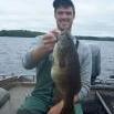
    • Rick G
      Crazy windy again today.... This is has been the norm this spring. Between the wind and the cold fronts, fishing has been more challenging for me than most years.  Panfish have been moving in and out of the shallows quite a bit. One day they are up in the slop, the next they are out relating to cabbage or the newly sprouting lilly pads.  Today eye guy and I found them in 4-5 ft of water, hanging close to any tree branches that happened to be laying in the water.  Bigger fish were liking a 1/32 head and a Bobby Garland baby shad.   Highlight of the day way this healthy 15incher
    • monstermoose78
    • monstermoose78
      As I typed that here came a hen.  IMG_7032.mov   IMG_7032.mov
    • monstermoose78
      So far this morning nothing but non turkeys. 
    • monstermoose78
      Well yesterday I got a little excited and let a turkey get to close and I hit the blind!!
    • smurfy
      good......you?? living the dream..in my basement playing internet thug right now!!!!!! 🤣 working on getting the boat ready.......bought a new cheatmaster locator for the boat so working on that.   waiting for warmer weather to start my garden!!!
    • monstermoose78
      How is everyone doing? Holy moly it’s chilly this morning I stayed in bed and will hunt later today when it warms up.
×
×
  • Create New...

Important Information

By using this site, you agree to our Terms of Use and Privacy Policy. We have placed cookies on your device to help make this website better. You can adjust your cookie settings, otherwise we'll assume you're okay to continue.